
urbansheep@gmail.com
WhatWasThere — К вопросу об исторических слоях на картах: привязка не только к ландшафту и топонимам, но и к местам, различия в которых не видны даже вооружённым взглядом: User-generated site adds historical layer to Google Maps - Springwise - http://www.springwise.com/lifesty...
|
26 февраля 2011 в 10:24 с Bookmarklet
королева амигдала
O!оценить
Dmitry Sergeev
kuchin
пойду-ка я поработаю
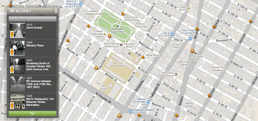
“WhatWasThere aims to add a new layer of historical context to the virtual atlas.
The WhatWasThere map appears, at first glance, to be no different from any ordinary Google Map. However, closer inspection reveals numerous geo-tags which, when clicked, display photos of the tagged area from the past. The photo is accompanied by a brief description, and there is even the option to view the photo in context at street level, using Google Street view to juxtapose the image against its modern surroundings. The project is entirely user generated, and the site welcomes users with an invitation to browse the map or upload their own historical photos.” - × × ×